From 3rd-15th July 2016, 3 personnel from Cambridge University Officer Training Corps joined 15 colleagues from 4 RIFLES and 4 MI Bn on Ex ARCTIC BUGLE, on a two-week Summer Mountaineering expedition to the islands of Kulusuk and Ammassalik in eastern Greenland. The expedition aim was to circumnavigate the mountainous island of Ammassalik whilst also allowing the novice members of the expedition to achieve their Summer Mountain Foundation qualification in a unique and challenging location. At an early stage of the planning process, Commanding Officer 4 RIFLES expressed a desire to include members of CUOTC in the expedition to further strengthen the bonds between 4 RIFLES and our partnered UOTC unit.
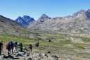
The team departed the UK on 3rd July, flying first to Keflavik in Iceland, transferring to Reykjavik domestic airport by bus, then flying onwards to the dirt strip on the tiny island of Kulusuk. The latter stages of the flight gave the exped members their first sight of the extraordinary scenery of Eastern Greenland; the massive ice sheet, huge glaciers, icebergs, dramatic peaks and blue and green lakes. The next day, we were transferred by small boat across Ammassalik Fjord to the town of Tasiilaqwhich would be the start and finish point of the expedition. The plan called for an anti-clockwise route around the island, heading first north for two days following a line of lakes inspiringly named Number 1 to Number 5 before swinging west to the coast and final returning to Tasiilaq via the south-west corner of the island. From the very first day it was quickly apparent that the expedition was to be a considerable challenge; scree and boulder fields, glaciers, steep slopes and deep, very cold rivers all hindered progress, whilst thousands of mosquitoes stood ready to bite any exposed flesh. However, these discomforts were more than compensated for by spectacular scenery, perfect weather and a unique cultural experience.
With unfamiliar 1:100000 mapping and large 25m contour intervals, some of the features on the route proved surprising challenging even for the more experience members of the expedition. A great deal of frost shattering has occurred in the area, resulting in a large number of rock fragments covering the hillsides. Progress at times was down to 1-2kph when passing through these areas in order to reduce trips and slips. The groups became very adept at fording rivers and utilised almost every technique in the book to safely cross. The intense cold of a knee-deep river below the Mittivakat Glacier was one of the most character-defining aspects of the entire trip. By day 3, the team had reached the northernmost point of the route and it was decided to break-track and climb an unnamed 600m peak. The summit gave us perhaps the best view of the entire expedition; unobstructed views to the vast Greenland Ice Cap 20km to our north-west as well as a grandstand view of glaciers that surrounded the peak on 3 sides. Camping each evening would have been extremely pleasant without the thousands of mosquitoes plaguing our every campsite! The Riflemen and Officer Cadets were somewhat bemused to find themselves armed with a Rifle on Polar Bear Stag during rest periods, and the 24-hour sunlight proved to be an unusual experience for all.
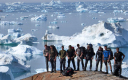
Days 4 and 5 saw the team moving west, then south to pass around the tongue of the spectacular Mittivakkat Glacier. Here the terrain became steeper and the navigation became much tougher. The large amount of iron present in the rock combined with a Grid Magnetic Angle in excess of 25 degrees to make direction-finding a challenge for the novice expedition members, but no-doubt has made them highly competent navigators. Arriving at Sermilik Fjord on the west of the island, the team were greeted by the sight of a perfect sandy beach and thousands of icebergs floating down the Fjord, presenting yet another memorable image for everybody. With supplies and energy running low, there was some relief to know that we had reached the final leg of the expedition, the route across the mountains back to Tasiilaq. Day 6 would prove to be the toughest leg so far, as the group passed directly over a 600m mountain, its slope covered with a fine gravel that made purchase extremely difficult. The weather also changed, dropping about 8 degrees and a chill wind developing, although mercifully the expected heavy rain held off. For the last day, the sun re-emerged, allowing for a surprisingly easy and relaxing walk down into Tasiilaq from the mountains. The total distance travelled, approximately 80km, hides the true challenges of the expedition; the contours, the going and the weight carried. The first order of business on arrival at Tasiilaqwas naturally to head to the only restaurant in town a pizzeria in a shed.
The group stopped in Iceland on the return journey for two days for some well-earned R+R, experiencing the natural water-spout at Geysir and spending a morning in the re-invigorating waters of the Blue Lagoon. Ex ARCTIC BUGLE proved to be a real once-in-a-lifetime opportunity to visit an amazing part of the world and will doubtless be remembered for years to come by all involved. I would like to extend a sincere thank you to all the team at the Ulysses Trust for both financial assistance and practical advice, in particular Roy McCluskey who was extremely helpful during the planning stages.
Capt Charlie Barrett, OIC Ex ARCTIC BUGLE